RIT Named a Finalist in Google Street View Contest
Winner becomes one of the first universities included in high-tech street mapping gallery
Voters have until Nov. 30 to help bring the Google Street View ‘trike’ to RIT.
Mapping the rapid transformation of the Rochester Institute of Technology campus is no small undertaking, so who better than Google to help bring those changes to life. The company has named RIT as a finalist to become one of the first universities to join its Street View Gallery.
Google’s Street View gives users a 360-degree street-level look at important landmarks and attractions across the United States. Its first use on a college campus featured a promotional campaign for the University of Pennsylvania. Now Google is looking to map the walkways and quadrangles of a different university.
As part of a contest sponsored by the company, RIT was selected among five universities to potentially be showcased using Street View technology. The other campuses are Arizona State University, Michigan State University, Stanford University and Princeton University.
Request for nominations in various categories, including colleges and universities, resulted in more than 25,000 submissions. Other notable landmarks under consideration for the contest include Alcatraz Island, Central Park, Faneuil Hall, Kennedy Space Center, National Mall, and the San Diego Zoo.
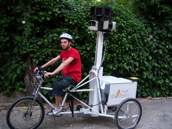
If selected, Google will send to RIT a tricycle, which tows a device the company says is “reminiscent of an ice cream cart” that has nine directional cameras mounted above it. It also includes a GPS unit for positioning and laser range scanners. The “trike” would then cruise around campus and snap photographs, providing a continuous stream of 360-degree images that are later organized to create Street View.
Recommended News
-
June 26, 2024
![A groupf of NASA technicians lift the Webb Telescope using a crane to move it inside a clean room at NASA's Goddard Space Flight Center.]()
Like a time machine
CITY features Jeyhan Kartaltepe, associate professor in the School of Physics and Astronomy, in a review of Rochester's contributions to the James Webb Space Telescope and space exploration.
-
June 26, 2024
![Five business-dressed people stand in front of sign that reads Saponia.]()
Student completes project with international company through RIT’s global connections
Reagan Brenneman ’24 (applied mathematics) had the opportunity to combine her multiple areas of study into an international experience working for the company Saponia in Croatia.
-
June 25, 2024
![Student and professor work on laptop on college campus]()
RIT researchers develop cybersecurity protocols for future smart transportation systems
RIT cybersecurity researchers are preparing connected vehicle networks for the next stage of cybersecurity—the post-quantum era. The team, in RIT’s ESL Global Cybersecurity Institute, is highlighting how current cryptographic methods are vulnerable to attacks enabled by emerging quantum computers.
-
June 21, 2024
![An illustration of a solar cell, with several layers, being struck by two beams, one red and one green.]()
Space radiation can damage satellites − my team discovered that a next-generation material could self-heal when exposed to cosmic rays
An essay by Ahmad Kirmani, assistant professor in the School of Chemistry and Materials Science, published by The Conversation.


