RIT Conducts Flood Mapping of New York’s Hard-Hit Schoharie County
Images will aid recovery planning and damage assessment
RIT Digital Imaging and Remote Sensing Laboratory
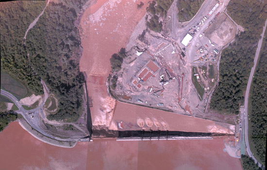
RIT captured high-resolution color imagery of water overflowing the Gilboa Dam on Aug. 30. Several images were stitched together and provided to New York State Office of Emergency Management within four hours.
The New York State Office of Emergency Management is using imagery of the widespread flooding in Schoharie County captured by Rochester Institute of Technology and Kucera International Inc.
On Tuesday, a crew from RIT and Kucera International remotely imaged the destruction in eastern New York caused by downpours from Tropical Storm Irene. The downgraded hurricane caused devastation along the Schoharie Creek and the Mohawk River west of Schenectady.
RIT engineer and sensor operator Jason Faulring and Kucera pilots Rebecca Heller and James Bowers flew a twin engine Piper Navajo over the entire flood zone. They covered 28 square miles, capturing 1,400 images during the 3.5-hour flight.
State emergency managers are accessing images of the entire flood zone, including high-resolution imagery of the towns of Middleburg, Schoharie and Prattsville, as well as the Gilboa Dam for damage assessment.
“One of the sensors is a shortwave infrared camera that is good for flood mapping,” says Don McKeown, project manager and distinguished research scientist in the Digital Imaging and Remote Sensing Group in RIT’s Chester F. Carlson Center for Imaging Science. “The state office of emergency management will use the imagery for recovery planning and damage assessment.”
The National Geospatial-Intelligence Agency and the Federal Emergency Management Agency also have requested access to the data. Researchers at State University of New York at Buffalo are also planning to use the imagery to assist in the development of improved watershed models for future events.
Mapping the flooded region in New York is the second disaster-imaging mission for RIT and Kucera International. The Schoharie County images were captured using the same sensors employed in Haiti following the 2010 earthquake. Faulring operated the sensor system RIT developed for the U.S. Forest Service—the four-camera system combines high-resolution color with infrared imaging; Bowers operated Kucera’s LIDAR sensor, the optical analogue to RADAR that uses laser pulses to make precision elevation measurements.
The report, “Disaster Relief 2.0: The Future of Information Sharing in Humanitarian Emergencies,” attributed RIT and industry partner ImageCat for transforming the work of the Haiti response effort by capturing and releasing to public domain aerial imagery of the earthquake’s aftermath. The report was issued in the spring and prepared by the United Nation Foundation, UN Office for the Coordination of Humanitarian Affairs, Harvard Humanitarian Initiative and Vodaphone Foundation Emergencies.
As a result of Haiti, we learned a lot of lessons about processing and how to do it and we came up with an automated processing flow,” McKeown says. “Jason [Faulring] did a whole day’s processing in an hour and a half. We’re light years ahead of where we were during Haiti.”
RIT and Kucera International are partners through the National Science Foundation-funded Information Products Laboratory for Emergency Response, a collaborative effort between RIT and UB to match remote sensing technology with the needs of emergency responders.
“The thing that highlights the function that we’re performing with IPLER is that not all the problems are technical,” McKeown says. “Realizing the state and federal funding constraints, and the critical need to assess the impact of the damage to help those citizens most immediately affected, we felt that imagery-based information could be very useful, so we stood up to the plate. Kucera donated flight time and LIDAR sensor data for the operation. We were able to use funding from our U.S. Department of Homeland Security grant to cover RIT’s efforts, as this kind of mission is exactly what this research program is designed to address. As a result, we were able to provide this information at no cost to the New York state taxpayer.”


