Scientists, alumni honored for work on Landsat 8
Imaging scientists on calibration/validation team win prestigious award
U.S. Geological Survey
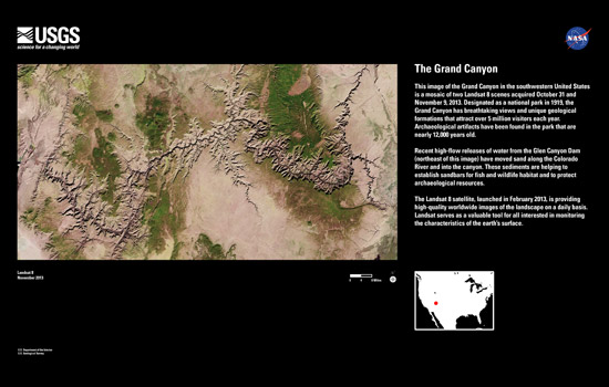
Mosaic of the Grand Canyon made from two scenes acquired by the Landsat 8 satellite on Oct. 31 and Nov. 9, 2013.
Scientists and alumni from Rochester Institute of Technology’s Chester F. Carlson Center for Imaging Science were recognized as members of the Landsat Calibration/Validation team with the 2013 Robert H. Goddard Award for exceptional scientific achievement.
John Schott, research professor; Nina Raqueno ’87 (BS, imaging science) assistant scientist; and Aaron Gerace ’10 (Ph.D., imaging science), associate scientist, in the Center for Imaging Science are on the 52-member team that also includes RIT alumni Julia Barsi ’97, ’00 (BS, MS, imaging science), and Matthew Montanaro ’05, ’09 (BS, physics; Ph.D., imaging science), Landsat calibration scientists who work for Science Systems and Applications Inc. and the Sigma Space Corp., respectively, as contractors to the NASA Goddard Space Flight Center in Greenbelt, Md.
“This award recognizes the significant effort put in by the entire Landsat Calibration/Validation team, and in particular the role played by faculty, staff and numerous students in the Center for Imaging Science over the years,” said David Messinger, associate research professor and director of the Digital Imaging and Remote Sensing Laboratory. “The fact that our students have the chance to work on these problems while here at RIT, and then go on to work directly in support of these NASA programs after graduation, speaks to the uniqueness of the imaging science program and the quality of our students.”
Landsat 8 continues the program’s 40-year imagery record of the Earth’s surface—measuring the health of its forests, fresh water supply, global crop production and glacial retreat. RIT has supported the NASA program with calibration efforts since the mid 1980s, starting with Landsat 4, Schott said.
In addition to NASA Goddard Space Flight Center, RIT’s affiliation with the Landsat program puts the university in the company of U.S. Geological Survey, Ball Aerospace & Technology Corp., South Dakota Sate University, University of Arizona and the Jet Propulsion Laboratory.
The calibration/validation team overcame challenges created by the use of advanced sensor technology for collecting images—the Operational Land Imager and the Thermal Infrared Sensor carried by Landsat 8 on its February 2013 launch.
The instruments’ complicated calibration required new methodologies and algorithms for the tens-of-thousands of detectors to collect, process and geolocate light reflected and emitted from the Earth’s surface. The Landsat Calibration/Validation team continues to monitor the sensors to maintain a consistent and accurate record over time.
