Maps and Directions
- RIT/
- National Technical Institute for the Deaf/
- Admissions & Aid/
- Maps and Directions
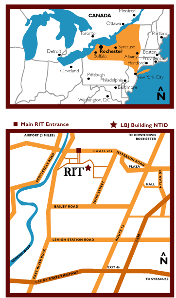
RIT's campus is five miles from both the Greater Rochester International Airport and the New York State Thruway (Interstate 90), exit 46. We are located eight miles from downtown Rochester train and bus depots.
Find the RIT campus on Google Maps, Yahoo! Maps, Bing Maps, or MapQuest.
For help finding specific buildings and other campus locations, download the campus maps here.
Rochester is served by Greyhound and Trailways bus lines and Amtrak. The Greater Rochester International Airport is served by most major airlines, including USAirways, United, Delta, American, and others. Taxis are available at the train and bus stations as well as the airport. RIT is a stop on Route 24 of the Regional Transit Service, the area's mass transit bus system.

From the airport
Turn right onto Brooks Avenue, then a quick right onto I-390 South. From 390, take the next exit (Scottsville Road) and turn right at the end of the ramp. Drive for approximately three miles, then turn left onto Jefferson Road (Route 252). Proceed east a short distance to campus. Turn right onto campus, just before the Radisson Inn, via Lowenthal Road (the third entrance onto campus from this direction).
From I-390 (Northbound)
Take Exit 13 (Hylan Drive). Turn left onto Hylan Dr. and continue north to Jefferson Road (Route 252), and turn left at the light. Proceed west a short distance to the main campus. Turn left onto campus, just past the Radisson Inn, via Lowenthal Road (the first entrance onto campus from this direction).
After entering campus
Directions to NTID Admissions: At the first stop sign on Lowenthal Road, you will see the Lyndon Baines Johnson (LBJ) Hall straight ahead. Make a left turn onto Andrews Memorial Drive. Take an immediate right and proceed to L Lot for parking. Proceed to LBJ Hall and enter the main lobby. The NTID Admissions Office is located to your left, at the end of the hallway in suite 1200.


